Why Hexcrawl?
A good hexcrawl is not a travel simulator. It’s a structured uncertainty engine. It trades scripted plot for layered geography, living factions, shifting risk envelopes, and consequential navigation choices. The map is the argument of play: “What do you do next?”
I’ve broken this into repeatable layers you can actually use at the table.
Layer 1: Purpose Before Parchment
Before you draw a single river ask:
- What pressure pushes people outward? (Famine, war, prophecy, scarcity, mandate)
- What resists encroachment? (Terrain, weather, curse zones, political interdictions)
- What rewards deeper push? (Relics, fertile basins, lost routes, metaphysical leverage)
- What changes if the region is fully mapped? (Shifts economy, unlocks factions, unleashes sealed threat)
Write three sentences answering those. Everything else hangs off them. Put them in your referee notes margin. If something doesn’t serve one of those sentences, eject it.
Layer 2: Scale & Discipline
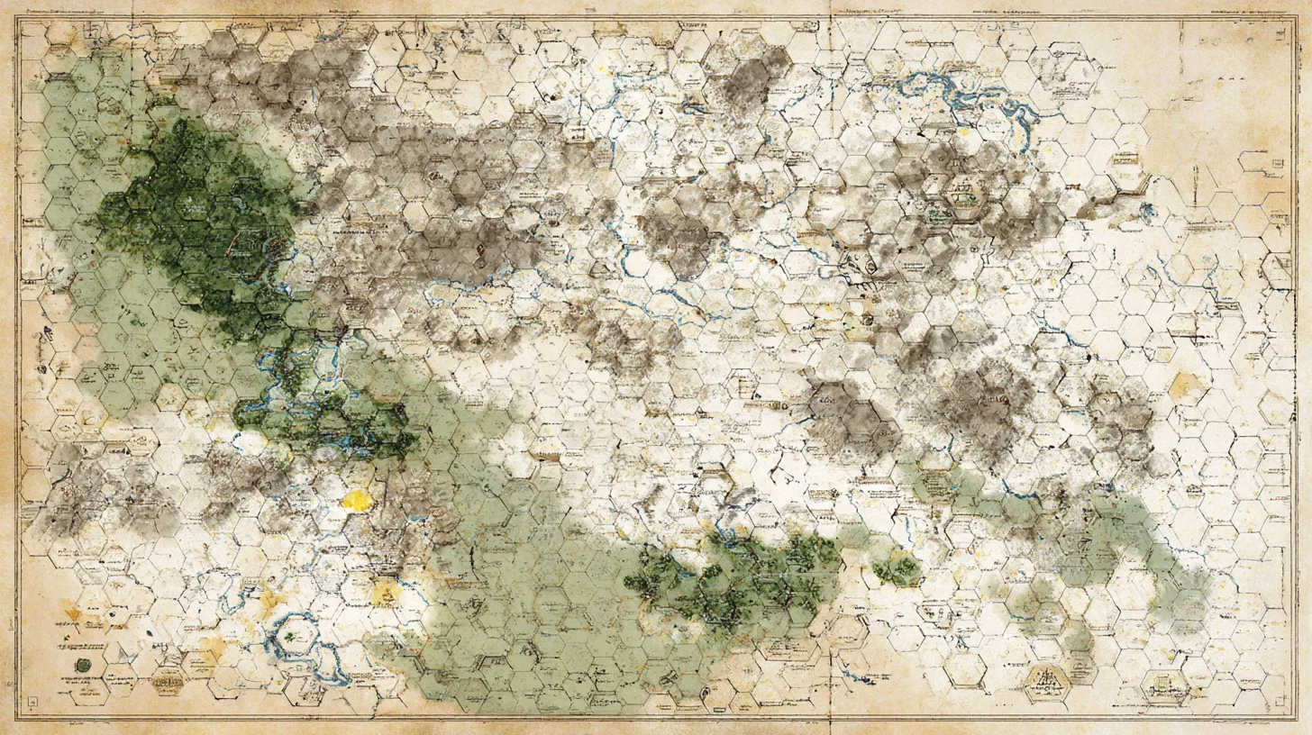
Three-Level Hex Zoom Cascade (36 → 6 → 1 Mile)
This streamlined model keeps only three practical tiers: a broad strategic frame (36), the classic daily exploration layer (6), and the tactically precise local layer (1). Fewer tiers = faster prep and clearer player mental maps.
36 Miles per Hex – Strategic Region
- Use: Map large territories spanning multiple polities or sweeping frontier zones; establish macro terrain, major routes, and anchor regions.
- Tactical Zoom Trigger: When players focus on a borderland, frontier, or specific kingdom segment — zoom to 6-mile hexes for wilderness-ready play.
-
Example Settings:
- Iberian Peninsula (Reconquista arc)
- British Isles (Viking or Saxon pressures)
- Silk Road steppe / caravan corridor
6 Miles per Hex – Wilderness Exploration Core
- Use: Primary hexcrawl layer; one hex ≈ a day’s mixed-foot travel (adjust for terrain). Stock anchors, active sites, and anomalies here.
- Tactical Zoom Trigger: Approaching a keyed site cluster, settlement environs, complex valley, or battlefield — zoom to 1-mile hexes for spatial choices.
-
Example Settings:
- Contested marches / border counties
- Mountain basins & upland plateaus
- Great forest interiors / national parks analogs
1 Mile per Hex – Local Tactical Detail
- Use: Site adjacency, farmland rings, fortress approaches, hamlet clusters, environmental micro-features; supports precise approach vectors.
- Tactical Zoom Trigger: Entering settlement limits, staging an assault, micro‑navigating hazards, or transitioning to dungeon / structure / battle maps.
-
Example Settings:
- Walled town + fields + mills
- Fortified pass choke & watch towers
- Estate, quarry, or battlefield layout
Integrated Scale Cascade Table
| Tier | Hex Size | Scope | Tactical Zoom Trigger | Examples |
|---|---|---|---|---|
| 1 | 36 mi | Strategic region | Focus narrows to frontier zone | Iberian Peninsula, British Isles |
| 2 | 6 mi | Wilderness core | Approach a keyed/local site area | Border counties, mountain basins |
| 3 | 1 mi | Local tactical | Enter settlement / assault / setup | Town fields, forts, estates |
Multi-scale hex overlay (36 / 6 / 1 mile reference)</figcaption>
<canvas id="hex-multi-scale" style="width:100%;height:100%;display:block;border:1px solid var(--bs-border-color,#ccc);background:var(--bs-body-bg,#ffffff);"></canvas>
<div class="hex-controls" style="position:absolute;top:.5rem;right:.5rem;display:flex;flex-direction:column;gap:.25rem;">
  <button type="button" class="btn btn-sm btn-outline-secondary border" id="hex-zoom-in" aria-label="Zoom in" title="Zoom in (+)">+</button>
  <button type="button" class="btn btn-sm btn-outline-secondary border" id="hex-zoom-out" aria-label="Zoom out" title="Zoom out (-)">−</button>
  <button type="button" class="btn btn-sm btn-outline-secondary border" id="hex-reset" aria-label="Reset view" title="Reset view">⟳</button>
</div>
  <!-- Legend populated by hex-multi-scale.js -->
</div>
Drag to pan. Use buttons, mouse wheel, pinch (touch) to zoom, or reset.</figcaption> </figure>
Layer 3: Minimal Base Stocking
Stop trying to lovingly handcraft every cell. Seed with density bands:
| Hex State | % of Region | Content Goal | Examples |
|---|---|---|---|
| Anchor | 5–10% | Campaign identity | Capital, Mythic ruin, Great river confluence |
| Active | 15–25% | Drive decisions | Faction fort, Trade choke, Weather node |
| Lurking | 25–35% | Delayed reveal | Sealed vault, Rotting god husk, Dormant colony |
| Empty (textured) | 30–45% | Contrast & travel pacing | Broken causeway, Burn scar plain, Chatter dunes |
You only fully key Anchors and the first wave of Actives. Lurking slots get a one-line seed. Empties get a terrain note + a travel complication die.
Layer 4: Terrain = Decision Pressure
Every terrain tag should do work:
- Alter navigation cost
- Modulate encounter table composition
- Convey risk signals (auras, carcasses, weather signatures)
- Telegraph deeper structure (river direction implies mountain ridge, basalt flows imply old catastrophe)
Add one anomaly per 6–8 hexes: inverted waterfall, glassed crater ridge, migrating sinkholes. Players remember anomalies more than generic forests.
Layer 5: Encounter Architecture
Encounters are not random events; they’re state probes.
Daily Encounter Procedure (example):
- Morning: Weather shift / omen check
- Midday: Navigation hazard OR social contact
- Afternoon: Predator / territorial assertion
- Night: Camp complication / haunting / pursuit catch-up
Use different dice per zone (d8 civilized edge, d10 frontier, d12 deep) to widen variance.
Encounter Table Structure (d12):
- 1–3: Terrain expression (living geology, weather burst)
- 4–5: Faction patrol / scout / courier
- 6: Resource cache / salvage / spoor
- 7–8: Creature with motive intersecting party vector
- 9: Consequence echo from prior choice (fire spreads, rumor manifests)
- 10: Lurking site teaser
- 11: Environmental escalation (storm front walls travel, fae tide rises)
- 12: Clock advancement / front progression
Each result should ask a question back: Who sent them? What do you do with it? Do you press on? If a result doesn’t change player calculus it’s ornamental; cut it.
Layer 6: Time & Clocks
Keep three visible pressure dials:
| Clock | Segments | Advances When |
|---|---|---|
| Frontier Consolidation | 6 | PCs map anchor + report / Faction treaty |
| Sleeping Engine Wakes | 8 | Arcane extraction, seismic events |
| Famine Wave | 4 | Supply convoy lost / harvest delayed |
Mark segments on triggered encounters. When a clock fills, it re-keys 3–5 hexes (change occupants / conditions) and you tell the players what shifted. The world moves.
Layer 7: Travel Turn Loop (Referee Card)
I keep a simple loop card:
HEX TURN LOOP
1 Declare destination / vector
2 Check route known? If not -> navigation test
3 Mark movement (log hex ID) & decrement light/rations/water
4 Terrain feature? (if first entry) -> describe + question
5 Encounter slot resolution
6 Player actions (scout, forage, track, research, ritual)
7 Log notable state changes
Players learn this rhythm and start pre-planning actions at step 1.
Layer 8: Information Economy
Players decide better when information has tiers:
- Vague rumor (region-level: “South marsh breathes at night”)
- Directional sign (terrain cue: “Trees bent inland”)
- Confirming detail (multi-sense: “Pulsing heat ripples over mud”)
- Immediate hook (actionable: “Steam vents align like a rune circle”)
Reward triangulation: if they collect three independent confirms, grant a tactical advantage tag (e.g. +1 initiative in that hex type, skip first hazard roll, negotiate from strength).
Layer 9: Resource Tension Without Bean Counting
Track only deltas that affect decisions:
- Light: Safe navigation at night / reduces ambush chance
- Food: Force risk-taking if low (forage table may escalate clocks)
- Encumbrance Band: Normal / Strained / Overloaded (each band adds cost or slows hex rate)
Abstract ammo unless the fiction demands scarcity. Let weather + terrain be your meaningful attrition.
Layer 10: Factions as Mobile Terrain
Treat factions like shifting terrain overlays:
- Patrol zones (expand / retract based on clocks)
- Influence markers in hexes (affect encounter substitutions)
- Supply lines (cutting them rewrites future tables)
Give each major faction a stance matrix (Need, Fear, Leverage). An encounter can flip one cell. Progress visible.
Layer 11: Emergent Sites On Demand
When players laser-focus an empty-ish hex:
- Roll / pick one Lurking seed to mature early
- Add a terrain anomaly to justify why it was hidden
- Tie it to an advancing clock or faction motive
- Drop a choice fork: deeper delve, bargain, escalate risk
This keeps prep elastic and responsive.
Layer 12: Mapping Conventions Players See
Show them a cleaned layer (rivers, coasts, major ridges). Let player map evolves with:
- Dashed outline = uncertain edge
- Icon with circle = confirmed site
- Hollow icon = rumored site
- Color wash = hazard zone (after 2+ confirmations)
They will begin setting their own vector goals. Momentum happens when I ask less “What now?” and more “Are you changing plan?”
Layer 13: Failure Is Cartographic
Missed navigation? Don’t say “You’re lost.” Say: “You emerge at a basalt rim with steam fissures—this is Hex H13; your intended vector shifts one column east unless you backtrack (costs 1 watch). Proceed?”
Failure produces new known geography plus a resource or time tax. Nothing dead-ends. Even ambushes should teach about faction reach or terrain teeth.
Layer 14: Session Close State Log
At end of session capture:
- Hexes entered (ID list)
- New / changed sites
- Clocks advanced (segments + triggers)
- Faction state flips
- Resource bands crossed
- Outstanding player-declared goals
This lets you re-key or escalate surgically, not wholesale.
Quick Reference Tables
Terrain Complication (d8)
1 Sudden grade / scree field (slow)
2 Torrent surge cuts route
3 Swarming insects (disadvantage on Perception / Listen)
4 Heat shimmer / mirage masks ridge line
5 Rot fog (choose: detour or Constitution saves)
6 Territorial scent posts (foreshadow predator)
7 Slumped earth reveals ancient paving
8 Electromagnetic crackle disrupts compasses
Forage Outcome (d6)
1 Nothing; sign of overuse
2 Low yield; reduces one hunger band
3 Adequate; stabilize food
4 Rich pocket; bonus + omen sign
5 Dangerous cluster; encounter check at +2
6 Rare herb / catalyst; trade leverage
Weather Shift (d10)
1 Static. 2 Pressure drop omen. 3 Sudden wind shear. 4 Horizon wall cloud. 5 Needle rain. 6 Radiant cold inversion. 7 Lightning crawl along ground. 8 Rolling fog banks. 9 Sky glow aurora thread. 10 Cycle reset with anomaly.
Closing Principle
A hexcrawl thrives when procedures produce fiction the players want to interrogate. If you feel like you’re pushing them, pull back. Tighten your loops, sharpen anomalies, surface clearer questions. The wilderness will start talking. Let them choose how to answer.
Run fewer prep marathons. Run tighter cycles with higher information yield.


Comments
With an account on the Fediverse or Mastodon, you can respond to this post. Since Mastodon is decentralized, you can use your existing account hosted by another Mastodon server or compatible platform if you don't have an account on this one. Known non-private replies are displayed below.